Total Pageviews

Tuesday, October 27, 2015

Columnar Joints: No, NOT in Colorado, But in Svartifoss, Devil's Tower, and Giant's Causeway

     Columnar joints are spectacular, often very long, hexagonal features found in igneous basalts (that's basalts not bathsalts!). Three particularly well-preserved examples are in Svartifoss, Iceland,


Devil's Tower, Wyoming, USA,


and the Giant's Causeway in far northeastern Ireland.


       [To clarify, there are columnar joints in Colorado; they are just not as spectacular as in those three places.]

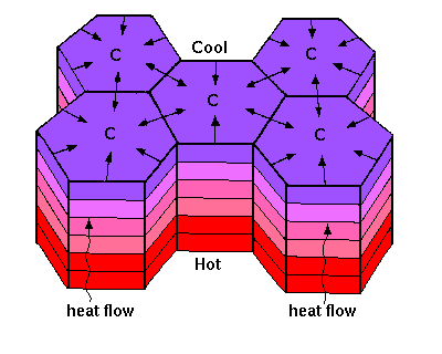
        The mechanism for creating these six-sided features is seen here where 'C' represents the center of each hexagon:


      This two-minute geology video shows columnar jointing from the side and from the top in eastern Washington, USA. The accompanying one minute video shows what happened to a rock hammer atop those hexagonal features!

        The columnar joints in Iceland have inspired architecture for a local church. I still think our first PEOTS field trip ought to be to Iceland.


         More information about this hexagonal packing structure, including T- and Y- junctures, points toward a similarity to the optimally-packed honeycomb:


. . .and to mud cracks. . .


and to carbon rings in chemistry (benzene here):


and to . . .


      Isn't nature mesmerizing?! And more than she's cracked up to be!?

Steph

P.S.

Hmmm, Ethiopia is likely ahead of Iceland in my travel plans, but Iceland is a close second. . .


Tuesday, October 20, 2015

The Last of the Trilogy: Mysteries of Great Sand Dunes National Park

      This is the third and final post on Great Sand Dunes National Park in south-central Colorado for this autumn. If you have not already read the first two posts, please read Part 1 and Part 2 first.

      A few mysteries about these 750 foot tall dunes, the tallest in North America, remain. What are these circular sand markings?


     [For scale, the notebook is about 4 inches by 2.75 inches.] Any ideas?

     Why did the National Park Service remove the road access through private land and Liberty Parking area from the northwest part of the official map? [I discovered the difference when writing notes on the map to send to my mom for our spring trip.]


       The map on the left was picked up directly from the GSD Visitor Center while the one on the right I picked up at the Nature Conservancy's Zapata Ranch. Hmmmm. Thoughts?

        I am most curious to trek to that northwest parking area to see the mysterious crater for myself:


(See also Part 2 of the GSD Trilogy for a discussion of the possible crater origins and comparison to similar erosional cirque features in Israel.)


     Not a mystery: the wonderful wheelchair dune buggies available at the Visitor Center for accessing the dunes


      and the Sawmill Canyon Backcountry Campsite along the Medano Creek Road which is expressly for providing a back country experience to those who use wheelchairs.


      The accommodations  have prompted a visit in November by a friend who needs the wheelchair dune buggy to fully experience the dunes.

       And lastly, Maizie is digging in the dunes link below.  Is she hot, looking for water, looking for gold or. . .What is it Maizie?

    Here's the last Great Sand Dunes images (well, at least until the spring. . .).


Here's hoping your National Park adventures are full of mystery and intrique.

Steph
  

Thursday, October 15, 2015

From "The Sound of Silence" to "Slip Sliding Away": The Great Sand Dunes and the Music of Paul Simon

     As the quietest of all of our 58 national parks, Great Sand Dunes National Park's theme song could readily be Paul Simon's "The Sound of Silence."


     The soft sounds of the blowing sand are often the only noises heard from the spectacular, relatively new adobe and wooden beams Visitor Center


                   or out on the dunes


            or watching "sand snakes"


or just taking it all in. Thirty square miles of dunes up to 750 feet tall is a lot to ponder. . .


and can be exhausting.


 Maizie is loving soaking up the sunshine as she takes this "Advice from a Sand Dune" very seriously.


          LiDAR (Light detection and Ranging) mapping of the San Luis Valley in 2011 (which includes the Great Sand Dunes) shows that the volume of sand is 1.5 cubic miles or 6.5 billion cubic meters (minus at least a cupful in my clothes, shoes, and camping gear). The San Luis Valley is the size of Connecticut, USA.


     LiDAR has also accurately mapped Star Dune at 750 feet, five dunes over 700 feet, and 37 dunes over 600 feet tall. LiDAR was responsible for mapping the Crestone Crater, a bowl-shaped depression about 100 meters (300 feet) across. The "crater" is of unknown origin but could be akin to the 5 makhteshim in Israel (thanks, SuperZee!) which are erosional cirques and not true craters of volcanic or meterorite origin.

      The earworms of "I am a Rock" and "Loves me Like a Rock" played often at the dunes


as did "Kodachrome"


and "Patterns"


     We drove less than a mile past the "Point of No Return" point on the Medano Back Country Road (Medano is Spanish for sand dune and is pronounced MED-a-no). Paul Simon's "Slip Sliding Away" was particularly apt and played long after that afternoon's adventure. Even with tire pressure lowered to 20 psi, it is quite a ride. . .


      This deer did not appear to have experienced "A Bridge over Troubled Water."


          We certainly did not have any troubled water as we were "Homeward Bound" after swimming in and camping near local hot springs:


*********Ahhhhhhhh.*********

Do you have a favorite Paul Simon song connected to a National Park memory?


Yes, we are duned!
Steph


Tuesday, October 6, 2015

Great Sand Dunes National Park: Kinky Dunes and Funky Surges

     Great Sand Dunes National Park in Colorado is home to breath-taking 750-foot tall sand dunes, the tallest sand dunes in North America.


       The ever-changing dune field is nestled up against a kink in the Sangre de Cristo Mountain range just east of the dunes and covers over 30 square miles.


      It is also home to the pulsing or surging Medano Creek which flows in the spring. The surge feature is a unique hydrologic phenomenon seen in this two-minute video. The National Park Service describes the connection between water, sand, and slope causing the surging flow as being akin to ocean waves. This excellent link on surge features describes Medano Creek and other surface creeks and the underlying water table as similar to the circulatory system of the human body.


     The 150,000 acre dune field is also home to the Tiger beetle, found only at the Great Sand Dunes.


         The San Luis Valley graben that contains the park (and the adjacent horst that includes Mt. Zwischen) is one of the northernmost reaches of extensional Basin and Range  that dominates the state of Nevada. The San Juan mountains border the graben to the west.


      In 1807, Zebulon Pike described the dunes, "Their appearance was exactly that of a sea in a storm (except as to color), not the least sign of vegetation existing thereon."


      Streams and creeks flowing out of the San Juan Mountains to the west over millennia carried gravel and sand into shallow lakes or sabkhas (salt flats) in the San Luis Valley. 


       During drought periods, these lakes dried, releasing the sand particles to the action of the wind. Strong prevailing southwesterly winds carry the tiny grains toward the Sangre de Cristos, piling them up against the foothills. 


      Yes, in the name of science and PEOTS, Maizie and I will be traveling southward this week to report on the state of the dunes. (Yes, we sacrifice for this blog!)


     Have you been to the Great Sand Dunes? Before or after 2004 when it was elevated from National Monument to National Park status?

From the sand dunes ocean state,
Steph


Cattle guard sign just south of the Great Sand dunes (Everything is pristine and quiet at the dunes. . .)