Total Pageviews

Saturday, March 12, 2022

Pi Day: Is there a Connection Between Meandering Rivers and Pi?

                     Welcome back!


        Partial Ellipsis of the Sun has been on a bit of a hiatus

but we're back just before Pi Day, 3/14/23.  You'll notice new comment form verbiage near your comment box. We're hoping for more regularity in our posts in 2023 as we approach our ten year blogiversary this October.


      A 1996 article in Science by Hans-Henrik Stolum posited that theoretically there may be a connection between the average overall lengths of rivers and pi. The authors saw an average variability in "wiggliness" or meandering vs. a straight line that approached 3.14. Noting the circular nature of the bends (which often become oxbows over time) compared to a straight line, this seems plausible.   


I was curious that this correlation has not been cited in extensive further research. This 2015 article by James Grime discusses those results:


   "Of the many weird and wonderful facts about pi, one of my favourites is a surprising connection between the number 3.14 and the world around us.

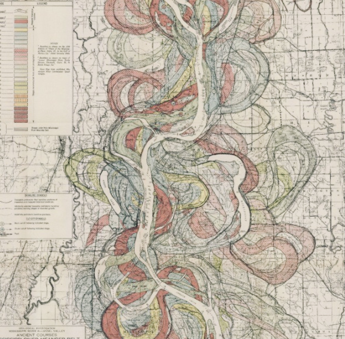
    It’s about rivers. Or more precisely, the bendiness of rivers.

    One can measure how “bendy” a river is by measuring its total length and dividing by straight route from its source to mouth, this measure is called “sinuosity”. So a totally straight river would have a sinuosity of 1, while very bendy rivers can have very high sinuosity, with no limit to how high it can go."


      Hans-Henrik Stølum, in the 1996 paper cited above, used empirical data and simulation to study the behavior of a river’s form over time, noting that the value of sinuosity tended to oscillate between a low-value of 2.7 and a high-value of 3.5, but with an average sinuosity of 3.14.

      "Stølum justified this result using fractal geometry. This is the idea that if the bends of a river can be approximated by arcs of circles, and the little wiggles of a river by arcs of smaller circles, then the sinuosity of the river can be calculated to be pi."


        After looking at Google Earth and other sources, including crowdsourcing via PiMeARiver.com for a small sample of only 258 rivers, Grime found the average sinuosity was 1.94.

        The close distribution of the data is evidence that the average sinuosity of rivers is around 1.94 in his small data set.

         "Bends in rivers are caused by erosion. As the water moves faster on the outside of a bend more erosion occurs, while soil deposits on the inside of a bend. This causes bends in rivers to become increasing more wild, increasing its sinuosity – until the bend becomes so extreme that the water can take a shortcut, cutting of the bend and forming an oxbow lake."


        "The formation of an oxbow lake results in that section of the river suddenly becoming straight, lowering sinuosity. So it is erosion and the formation of oxbow lakes that are the two driving forces behind a river’s sinuosity. Over time this results in rivers behaving chaotically, with the value of sinuosity oscillating between high and low values. It was while studying this chaotic behavior that Stølum first noticed the value of pi."


        "If the true value of average river sinuosity is smaller than pi, maybe we need to consider another mathematical constant? Like the golden ratio, aka phi (1.618)  which is also found in the fractal behavior of nature. This phi value of 1.618; the ratio of pi/phi is 3.14/1.618 we get 1.94." Grimes questions "Coincidence, or something more?"

           Or -- we definitely need more data!


         Simon Singh discusses pi and rivers in his book Fermat's Enigma: The Epic Quest to Solve the World's Greatest Mathematical Problem.

          Citing Stølum’s finding, Singh notes:

"The number pi was originally derived from the geometry of circles, and yet it reappears over and over again in a variety of scientific circumstances. In the case of the river ratio, the appearance of pi is the result of a battle between order and chaos. Einstein was the first to suggest that rivers have a tendency toward an ever more loopy path because the slightest curve will lead to faster currents on the outer side, which will in turn result in more erosion and a sharper bend. The sharper the bend, the faster the currents on the outer edge, the more the erosion, the more the river will twist, and so on. However, there is a natural process that will curtail the chaos: increasing loopiness will result in rivers doubling back on themselves and effectively short-circuiting. The river will become straighter and the loop will be left to one side, forming an oxbow lake. The balance between these two opposing factors leads to an average ratio of pi between the actual length and the direct distance between source and mouth."


           Chaos and order:   What are your thoughts on pi and rivers?


            HAVE A GREAT PI DAY!


Tuesday, March 8, 2022

From Circles to Squares and Back Again: Sandhill Crane March Migration, Crestone Conglomerate, and a Surprise Stupa!


     A trek to the San Luis Valley in southern central Colorado over the first weekend in March yielded many surprises. The Greater Sandhill Cranes are majestic as they "swim" in air currents, legs dangling akimbo.


      We observed the up to 1.25 meter tall birds on a particularly raw and windy day. You can see the cloud above looks like it is just about ready to land in the farmlands of the expansive, extensional basin.


      The cranes (believed to bring souls from Earth to Heaven in some cultures) swoop and dance and disappear into the Davy's-gray-colored clouds surrounding Monte Vista National Wildlife Refuge (NWR).


     The soothing and melodic sounds of the thousands of cranes in the Monte Vista Wildlife Refuge that blustery March day were shared with my friend, Barbara, her little black dog, Zelda, and of course, Bruno, my little white dog. We saw only one other group (with large telephoto lenses) and a couple of other cars all that grey morning (Thanks, James Taylor). There's a teeny patch of blue on the left side.


       We drove in large squares around and through the refuge and south of town. The squares of that day were in sharp (pun intended) contrast to the circular shapes of our rented dome house in the Baca area of Crestone, just south of the Baca NWR. Baca means "the topmost part of something or, literally, roof rack."


     The dome house provided ethereal light from 1.5 meter diameter windows and majestic views of the Sangre de Cristo Mountain Range. It was created by popping a 10.35 meter in diameter balloon to create the distinctive dome shape. Waking up to see dark skies and myriad stars was magical.


     The biggest surprise of the weekend was heading south out of Crestone about 13 km along a fairly beat-up dirt road toward the northern edge of the Great Sand Dunes (or so we thought). We passed a water tank and rounded a challenging corner to discover a Surprise Stupa (www.kttg.org). There are no signs along the way. It just is. It rises and looks over the down-dropped graben that is the San Luis Valley. What a splendid and respectful place to be atop the foothills of the Sangre de Cristos!


    Surrounding the stunning Stupa are several rock walls containing many pieces of CrestoneConglomerate. Conglomerate is made up of pieces of the rocks that pre-dated them; they are forged in midst of catastrophic geologic processes. The conglomerate here contains both rounded and angular pieces:


      The sensation of people of different colors and religions coming together at the Surprise Stupa mirrors the conglomerate make-up.

       And to bring things full circle {full square (?)}, I drove all way from home to school yesterday with my coffee cup on the baca of my car! It was still 2/3 full when I arrived in the snow.


      More on the Crestone Conglomerate another time. . . 


      Have you been to Crestone?

With calm and surprising crest one vibrations,

Steph


Monday, January 10, 2022

Grappling with Graptolites: Paleozoic "Sawtooth" Index Fossils —Are you Jelly?

      Graptolites (or more precisely Graptolithina) are extinct colonial marine animals that are an excellent index fossil for parts of the Paleozoic period; individual species denote well-defined time frames within, especially, the Ordovician, Silurian and Devonian periods. The fossil remains present mostly as shiny, graphite-looking sawtoothed pieces. A big paleontology mystery up until the 1980’s was what these pieces represented. Early descriptors, including Linnaeus, were mystified by the “writing on the rock,” considering even hieroglyphics as a possible origin. He included them in “inorganic mineralizations and incrustations which resembled actual fossils.” In 1768’s, Systematic Naturae he included one species as a possible plant fossil. He also included a figure of a "fossil or graptolite of a strange kind.”


           These serrated, delicate, detailed fossils, represent about 200 million years from the Cambrian through the Pennsylvanian portion of the Carboniferous. 


           These useful Index fossils denote rocks to within a million year period within the Paleozoic.  The Ordovician was a particularly prolific time for graptolites, with rapid changes in morphology. In addition, early graptolites were sessile but rapidly evolved to be floating animals. Their fossil remains are found in shale and clay stone. Another prolific Ordovician index fossil, conodonts or conodont elements, are found mostly in limestone and other CaCO3-rich environments.{ More on conodonts during our next post.}


      Paleontologists use them to correlate the age of rocks, particularly mudstones or shales, based on changes in the serrated blades. Oil and gas geologists found graptolites particularly helpful in correlating borehole samples throughout a geologic basin. But, we didn’t have fossilized portions of the entire animal, just the shiny sawtooth bits.


            The rather shocking discovery of soft parts of the animal revealed graptolites resemble present-day jellyfish. These floating colonial animals had a proto-neural tube. But, only the floating strands of detailed serrated portions in the fossil record led to many incorrect hypotheses of their origin. Now, we believe graptolites looked like a an odd-shaped jellyfish as seen in these artists’ renderings:


              This rendering is even more bizarre:


      From long, shiny bit of graphite-looking straight shapes


  to the more elaborate swirling shapes, graptolites gave geologists a solid index fossil for use in oil and gas correlation between oil wells, long before we knew what the whole animals looked like.


The type 
locality for the Ordovician is located here in the U.K. As Ordovician. Note also, Silures, type locality for the Silurian, is located just to the south. {The Silurian was a time of great silence on the earth; almost no volcanic activity has been recorded during this Ordovician-adjacent time.}


Have you seen either graptolites or conodonts in rocks in the field? Odd that these two most unusual creatures would be the basis for so much geologic correlation, without knowing what the whole animals looked like. The Ordovician was a quite wild ride.

Happy New Year to all visitors to Partial Ellipsis of the Sun;we are glad you are here!

To 2022, with Great Expectations for Groundhog Day, 2/2/22! 
Steph

Bonus: Looking ahead: Here’s an image of  conodont elements in an SEM image as well as an artist rendering of the elements in the inside the mouth of that Ordovician beast, the stuff of nightmares. Conodonts, microfossils varied and extraordinaire, will be featured in our next post.


Tuesday, September 7, 2021

Codex of 15th and 16th Century Mexican Earthquakes (Tlalollin)


"The written chronology in a 16th century codex was created by a pre-Hispanic civilization.

 It is one of the oldest-known records of an earthquake which occurred in Mexico in 1507

(see below).


pictogram showing an earthquake and warriors in a river


       The earthquake is represented by the symbol (to the middle, right) 

composed of four dotted yellow rectangles representing the layers of 

the earth) overlain by four helices (in blue and white) with a red eye 

at the center. The pictogram also describes one impact of the quake

--the drowning of 1,800 warriors in a river (bottom).

          A 50-page codex of colorful, complex pictograms that dates to the early 16th century includes the most complete (and one of the oldest ) written chronologies of early earthquakes in the Americas.

      The Telleriano-Remensis, which was created by an unknown pre-Hispanic civilization, describes twelve separate earthquakes that shook in what is now Mexico and central America from 1460 to 1542 researchers report in the August 25, 2021 issue of Seismological Research Letters.       The famous codex was written by specialists called tlacuilos, meaning “those who write painting” in the Nahuatl language spoken byAztecs and other pre-Hispanic civilizations in the area (Science News, March 13, 2020).

      Using other codices from the region, researchers had previously identified the combination of two pictographs that denotes an earthquake. One shows four helices around a central circle or eye, and stands for ollin, meaning “movement” in Nahuatl. The other pictograph shows one or more rectangular layers filled with dots, and means tlalli, or “earth.” For daytime earthquakes, the eye is open; for nighttime quakes, it’s closed.

pictograph showing a central eye followed by a plus sign and a pictograph showing a box with dots
In codices written by pre-Hispanic civilizations who spoke Nahuatl, such as the Aztecs, the combination of two symbols represents an earthquake, or tlalollin. One pictograph (left) shows four helices with a central eye and stands for ollin, or “movement.” The second (right) is a rectangular box filled with dots, often in layers, and represents tlalli, or “earth.”

      Seismologist Gerardo Suárez of the National Autonomous University of Mexico and social anthropologist Virginia García-Acosta of the Center for Research and Higher Studies in Social Anthropology, both in Mexico City, pored over the Telleriano-RemensisThe researchers were looking for representations of quakes, comparing what they found to accounts of quakes in other pre-Hispanic codices and texts written later by Spanish friars.


     The Telleriano-Remensis uses a pictorial representation of a 52-year cycle to roughly date the quakes. Years are represented by these four signs:

tecpatl (knife), 

calli (house),

 tochtli (rabbit) 

and acatl (reed) 

which are arranged in thirteen permutations. Those images helped the researchers match some pictorial accounts of quakes, including one in 1507, to later descriptions of the events.

     Little more is recounted about the precise locations of these quakes or the damage they caused, although one image suggests that a quake triggered flooding that drowned several warriors. Other codices may contain more clues, the researchers say, which could help create a more complete chronology of the quakes that shook this part of the Americas."


Knife, house, rabbit, reed?

Codex Steph