Total Pageviews

Wednesday, August 19, 2015

"Nothing to See Here:" From Agates to Ashes >>> All Fall Down: The Fascinating Fossils of Nebraska

       Surely there must be "Something to See Here" in western Nebraska. . .


         And in eastern Nebraska, about 400 miles to the east along John McPhee's famed I-80 (more or less--both parks are actually closer to state route 20):


        The "USA Map According to Geologists" at the tail end of last week's blog is the inspiration for this look at fossils in far western and far eastern Nebraska (part of the area labelled "NOTHING TO SEE HERE.")


     Western Nebraska is home to Agate Fossil Beds National Monument, a fossil-rich area of Miocene age (23-5 million years ago).


       Three particular mammals are found in the main bone beds near Harrison, NB:


      (1) Menoceras, a small rhinoceros; (2) the large Moropus, an extinct horse relative ; and the (3) Dinohyus, an extinct giant, pig-like mammal.


        Another quarry site to the east (see map above) of the main bone beds is comprised almost entirely of the small gazelle-camel, the Stenomylus, and the burrowing dry-land beaver, the Palaeocastor. The final, rarer animal is the predator Daphoenodon from the extinct beardog family. The bear dog is neither (shades of honey bear-ness?). 


       In Eastern Nebraska the Ashfall Fossil Beds State Historical Park preserves an in situ fossil site with well preserved mammals, especially horses and rhinoceroses, reptiles, and birds.


     The well-preserved nature of the site is due to an ashfall plume (below) from Yellowstone National Park around 12 million years ago. The animals died more or less simultaneously near a water hole in eastern Nebraska. It is an active dig.


       Having driven both I-80 and State Highway 20, I highly recommend the latter for "SOMETHING TO SEE HERE."

Have you visited either site? I am most curious about those bear dogs. How about you?

Curiouser and curiouser,

Steph

This week's post is for my daughter, Zoë, who turns 22 tomorrow (in Ethiopia where she has already reached her Catch-22 birthday).


Tuesday, August 11, 2015

Gold King Mine, Colorado: Unplugged

     On August 5, 2015, at 10:30 a.m. the Environmental Protection Agency (EPA) breached a plug or dam on toxic mine waters near the Gold King Mine 


sending over 3 million gallons (originally reported by the EPA as 1 million gallons) of arsenic and metal-rich water into Cement Creek which flows into Las Animas River ("River of Souls") in southwest Colorado.


        Stephanie Paige Ogburn's 8/6/15 article (written just a day after the spill) is one of the more balanced compilations available as it pulls together geological background, mining history, and historical background about the relationship between the EPA and the Silverton community.

       "For years, the EPA has wanted to name areas around Silverton as a Superfund site. This brings funding for cleanups. The town, in turn, has resisted fearing the label would be toxic to tourism (pun intended.)"

      The EPA was well aware that high levels of toxic materials were in long-abandoned mine debris ponds. It is most unfortunate that the spill made its way into the Animas River (here near Silverton), has now entered New Mexico and Utah, enroute to Lake Powell: 


       In addition, the naturally-occurring ferricrete ("iron concrete") deposits in the area add to high levels of metals, sulphates and other toxins. The name Cement Creek was given for a reason. There haven't been many fish in this creek for decades, perhaps over a century. The disturbance of the mine's debris waters could have happened without the EPA's heavy machinery accident. This image shows the Red and Bonita Mine south along Cement Creek which also has very high levels of toxic materials:


     The EPA did not report the incident to the community for 25 hours (bad PR and outside EPA's own 24-hour reporting window). In addition, the original 1 million gallon reported EPA number could have easily been more accurately seen at the USGS stream flow and gage height site. I pulled these two graphs yesterday showing the 8/5/15 spike of 3 million gallons (with some multiplication of cubic feet per second (cfs) times the number of seconds in the second graph):


     All of these data are available online to the public.   

    The EPA today reported toxic material including lead levels that are 12,000 times the acceptable EPA levels. Arsenic, mercury and cadmium are also extremely high. Of particular concern is the cadmium level as cadmium is readily absorbed into plant material, posing a fairly distinct short-term risk to both the plants and any animals, including humans, who consume them. (Although, I wonder about these humans below and their decision to stay in their kayaks being directly exposed to the orange sludge): 


          I would enjoy hearing your thoughts about the Gold King spill,surrounding Silverton area mines, and Superfund sites. I am particularly interested in finding out who makes the ultimate Superfund site (National Priorities List or NPL) decision. The Animas River Stakeholders Group, which includes Silverton residents, business representatives, AND the EPA, appears to have the ability to say "yeah" or "nay" to the decision about the Silverton area.

Unplugged here,
Steph

      A marvelous part of my mishpokey, Zoë (in the orange shirt [what else this week?]) is headed today to the Amhara region (colored fuchsia on the map below) of Ethiopia for her Peace Corps service. Other groups will go to Tigray, SNNP, and Oromia.


       This "USA map according to Geologists" is both amusing and fairly accurate except for 1) "nothing to see here" (I am considering the Ashfall Fossil Monument in eastern Nebraska for next week's topic) and 2) "Too hot to do field work in summer" in southern AZ as that's where we did summer field work (yes, it was pretty hot!)


Tuesday, August 4, 2015

From Prolog(ue)s to Pro-Legs: Mugo Pine and The Redheaded Pine Sawfly


       I am fascinated by these redheaded pine sawflies (Neodiprion lecontei) on my geology professors' Mugo Pine (Pinus Mugo):


     The sawfly was not a major pest problem in Mugo and other pines in the U.S. until the planting of large pine plantations in the 1930's. 


     The sawflies resemble caterpillars but are actually members of the wasp/bee family, not the butterfly/moth family. Caterpillars have up to 5 pairs of abdominal prolegs. Sawfly larvae have six or more pairs of abdominal prolegs:  


       Another notable difference, though it requires a much closer look (oh, yeah!), is that caterpillars have tiny hooks called crochets, on the ends of their prolegs. Sawflies don't. Here are the crochets on caterpillars (C on C as a way to remember the "cats" [entomologists' affectionate pet name for caterpillars] differentiation from sawflies): 


       And the Scanning Electron Microscope version of the crochets:


      The common name of sawfly comes from the saw-like appearance of the ovipositor, or egg depositor, which the females use to cut into the plants where they lay their eggs.


      The insecticides that are used on the caterpillar family do not work on sawflies. [And, of course, many caterpillars transform into much-needed and wanted butterflies.]There are some wasp/sawfly insecticides that are somewhat effective, including organic diatomaceous earth (remember the diatoms from our Scanning Electron Microscope {SEM } discussion earlier?):


      However, one of the best ways to get rid of the sawfly larvae is to simply pull them off the Mugo pine trees. Any volunteers to get in there, count legs, and pull off the large clumps of sawflies? If so, they are in Northampton, Massachusetts, waiting for you. {Eric Carle used to be there, too, for over 30 years, though he recently moved southward to North Carolina and Florida.}


      Wonder if Eric Carle ever counted pro-legs on caterpillars. . .

      Any good caterpillar or sawfly tales? Might we count on you?

Steph

    Here is an image from the August 4, 2015, Las Animas River after a 3,000,000+* gallon spill from the Gold King Mine in southwest Colorado (see link to article in 8/7/15 comment):


     Indeed, next week's Partial Ellipsis will look at the Animas River Spill in Colorado. Please look there for a discussion of the Gold King Mine. I am cleaning up some of the graphs, have some new local photos to share, etc.

      *Updated from the original EPA estimate of 1,000,000 gallons.


Wednesday, July 29, 2015

Geologic Tools of the Trade: No Monkey Wrenches Here, Only Bruntonian Motion

     Thanks, Lego Joe, of Puzzleria! fame for the suggestion to write about geologic tools of the trade, an extension from the NPR Sunday Puzzle about auto mechanics' tools of the trade.

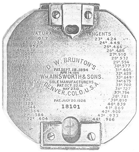
      My two favorite field geologic tools are my Brunton Compass:


and my Estwing rock hammer:


[It did look like this when it was new:]


          And now it looks like this (rock hammer, Brunton, and Brunton case):


     The Brunton compass is used primarily to take the strike and dip of rocks in an outcrop as described in this three-minute video.


    The Brunton compass (actually the Brunton Pocket Transit) is a precision compass made by Brunton, Inc. of Riverton, Wyoming. The instrument was patented in 1894 by a Canadian-born Colorado geologist, David W. Brunton. 


      Unlike most modern compasses, the Brunton Pocket Transit utilizes magnetic induction damping rather than fluid to damp needle oscillation. 


     From the Wikipedia article on the Brunton Compass:

      "With the advent of portable electronic devices a new generation of compasses has emerged, some again of specific interest to geologists. Unlike analogue compasses, a digital compass relies on an accelerometer and a teslameter, and may provide much information as to the reliability of a measurement (e.g. by repeating the same measurement and performing statistical analysis). Programmers of today's smartphones have responded with different geological compass apps. However, caution must be exercised: Because the Earth's magnetic field fluctuates rapidly, 'smartphone' 3 axis magnetometers can potentially measure noise. Furthermore, all smartphones create strong magnetic fields that must be corrected by computer algorithms. At present, all geological compass apps should be tested against traditional magnetic compass measurements."


     My trusty Brunton was also used for siting along with a plane table and alidade in barite mapping in Mexico. Here's a photo of Francisco who was my bodyguard and occasional rod man 


while I tromped around on the rocks, measuring strike and dip, sampling thick barite beds, and dropping acid 
(a mixture of Alizarin red S and potassium ferricyanide dissolved in a dilute hydrochloric acid solution)


 on rocks to determine if the carbonate was calcite (bright red or pink) or dolomite (white, brownish-grayish-greenish or clear). 


       I used my Brunton to measure the strike of metamorphic features in addition to sedimentary layers. The Brunton is still used by geologists, archeologists, and other scientists (though the price is now between $350-$700; I bought mine used for $75 and that was a really good deal.)

       My rock hammer has pounded on rocks from Spain to Mexico to all over the U.S. Field geology is a truly a blast!

       Two of my other favorite "tools?" A tractor and a backhoe used to dig trenches to get a better look at the thick barite beds beneath the surface in Cobachi, Sonora, Mexico. 


What's your most trusted tool?
Steph


Wednesday, July 22, 2015

DNA Ties between Indigenous People of Australasia and Amazon: Free Shipping Included?

     
     Yesterday, Harvard University researchers published research in the journal Nature which shows close DNA connection between indigenous peoples of the Amazon Basin of South America and aboriginal people of Australasia (including Australia, New Zealand, Papua, New Guinea and surrounding islands).


       The researchers looked at the data several times because it differed from their previous models of the spread of the human population. Skoglund et al found the genomic evidence to be even stronger as they looked harder to show there was not a tie between the two population groups.


        This summary article from Science Daily includes these paragraphs:

        "Skoglund and colleagues from HMS, the Broad and several universities in Brazil analyzed publicly available genetic information from 21 Native American populations from Central and South America. They also collected and analyzed DNA from nine additional populations in Brazil to make sure the link they saw hadn't been an artifact of how the first set of genomes had been collected. The team then compared those genomes to the genomes of people from about 200 non-American populations."


      "The link persisted. The Tupí-speaking Suruí and Karitiana and the Ge-speaking Xavante of the Amazon had a genetic ancestor more closely related to indigenous Australasians than to any other present-day population. This ancestor doesn't appear to have left measurable traces in other Native American groups in South, Central or North America."


      "The genetic markers from this ancestor don't match any population known to have contributed ancestry to Native Americans, and the geographic pattern can't be explained by post-Columbian European, African or Polynesian mixture with Native Americans, the authors said. They believe the ancestry is much older--perhaps as old as the First Americans."


        "The team named the mysterious ancestor Population Y, after the Tupí word for ancestor, 'Ypykuéra.' "

          The researchers propose that Population Y and First Americans came down from the ice sheets to become the two founding populations of the Americas.

       "About 2 percent of the ancestry of Amazonians today comes from this Australasian lineage that's not present in the same way elsewhere in the Americas," said David Reich, one of the contributing authors.

        An Australasian heritage for Amazonian people is one of the last connections that would come to my mind, given the geographical isolation of Australasia for such a long time period. What's your thinking about this migration pattern?

Two additional links on this topic from The New York Times and The Smithsonian.

Scratching my head over this one,
Steph

This world map projection is helpful:


     You can just about see Gilligan in the middle of the Pacific. . .

      And with the wind patterns:


Tuesday, July 14, 2015

If Only We Had Taller Been: New Horizons Makes the 3 Billion Mile Trip Past Pluto

       The startlingly clear images of dwarf planet Pluto's surface have captivated me all day. 


     Images from 3 billion miles from earth being transmitted by the New Horizons piano-sized probe have dominated nearly every news and science outlet. There's a Google doodle  and a New Yorker cartoon:


     Nine years after the 2006 launch we are treated to these false-color composite images of Pluto and Pluto's moon, Charon:


      There's even a New Horizons tribute with Ray Bradbury's voice reciting  If only we had taller been.

     For me, all of this spectacular imagery has me thinking about the U. S. space program's first probe of Mars on this very date (Bastille Day!) 50 years ago in 1965 . And, of course, the Moon Landing on July 20, 1969. 


       What is it about our space program and July?! Best time for good publicity? Best time for images? Other ideas?


All hail Pluto, the (round) dwarf planet and Happy Quatorze Juillet!

Steph

P.S. Hey. . .'Sup?


Thursday, July 9, 2015

Ethiopian Welo Opals, Oh Pals!

     Ethiopian opals from the Welo District include this spectacular specimen discovered in October 2013. 


     The Ethiopian Welo opal mines were first discovered in 2008 in the district north of the capital of Addis Ababa (although opal was said to have been discovered in the 1930's elsewhere in Ethiopia and minimal mining began in the 1990's):


       The USGS estimates 2012 production of Ethiopian Welo opal to be 14,000 kilograms or 31,000 pounds. This estimation would change Australia's purported 95-97 percent of the world's opal production. There is not much information currently available about the Ethiopian Welo opal mines. Perhaps my daughter, Zoe, can make a field trip to the north to discover more about their deposition (or I could visit her and the opal mines!). I am quite curious about the similarities between the depositional environments in Australia and Ethiopia. 


    Opal is a hydrated amorphous form of silica with a water content ranging from 3 to 21% by weight. Because of its amorphous character, it is classed as a mineraloid, unlike the other crystalline forms of silica, which are classed as minerals.


     Australian opal is generally of a higher water content than the Ethiopian Welo opal. It is also generally found in deeper environments. Opals which get too dry are said to "craze." Often gemologists store opals in water to keep them hydrated. I take mine swimming.


      This four minute long video of Welo opals is worth a look, oh pals!

       I like the fire and the setting of this Ethiopian opal.


     Speaking of Ethiopia, here's the Peace Corps group arrival at the airport in Addis Ababa. Where's Waldo (er, Zoe?!) What an enthusiastic bunch (especially just after a 13-hour plane ride)!


                                             ^
                  
O pals, let me know your silica thoughts,
Steph