Total Pageviews

Showing posts with label Peru. Show all posts

Tuesday, October 1, 2019

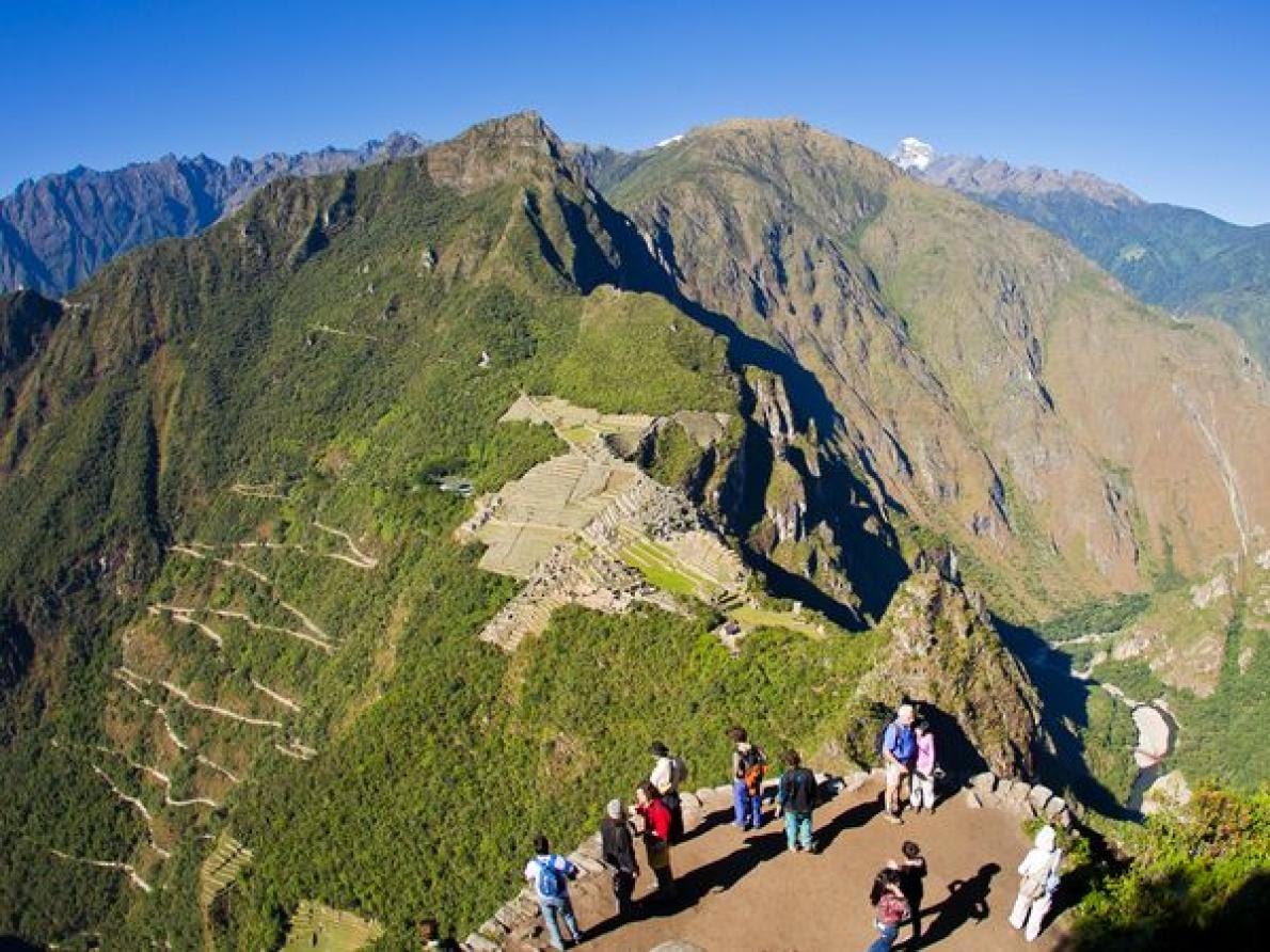
Machu Picchu: 15th Century Incan Sanctuary Purposely Built on Faults


     "The ancient Incan sanctuary of Machu Picchu constructed in the mid to late 15th century, is considered one of humanity's greatest architectural achievements. Built in a remote Andean setting atop a narrow ridge high above a precipitous river canyon, the site is renowned for its perfect integration with the spectacular landscape. Yet the sanctuary's location has long puzzled scientists -- Why did the Incas build their masterpiece in such an inaccessible place? Research suggests the answer may be related to the geological faults that lie beneath the site."(Wow, ancient ecoarchitects meet ancient Scientific Stephs ;-)).

       "On September 23, 2019, at the Geological Society of America (GSA) Annual meeting Dr. Rualdo Menegat, a geologist at Brazil's Federal University of Rio Grande do Sul,  presented the results of a detailed geoarchaeological analysis that suggests the Incas intentionally built Machu Picchu -- as well as some of their cities -- in locations where tectonic faults meet. "Machu Pichu's location is not a coincidence," says Dr. Menegat. "It would be impossible to build such a site in the high mountains if the substrate was not fractured."


    " Using a combination of satellite imagery and field measurements, Menegat mapped a dense web of intersecting fractures and faults beneath the UNESCO World Heritage Site. His analysis indicates these features vary widely in scale, from tiny fractures visible in individual stones to major, 175-kilometer-long lineaments that control the orientation of some of the region's river valleys."


     "Dr. Menegat found that these faults and fractures occur in several sets, some of which correspond to the major fault zones responsible for uplifting the Central Andes Mountains during the past eight million years. Because some of these faults are oriented northeast-southwest and others trend northwest-southeast, they collectively create an "X" shape where they intersect beneath Machu Picchu. X marks the Machu Picchu spot.


     "Dr. Menegat's mapping suggests that the sanctuary's urban sectors and the surrounding agricultural fields, as well as individual buildings and stairs, are all oriented along the trends of these major faults. "The layout clearly reflects the fracture matrix underlying the site," says Dr. Menegat. Other ancient Incan cities, including Ollantaytambo, Pisac, and Cusco, are also located at the intersection of faults, says Menegat. "Each is precisely the expression of the main directions of the site's geological faults."
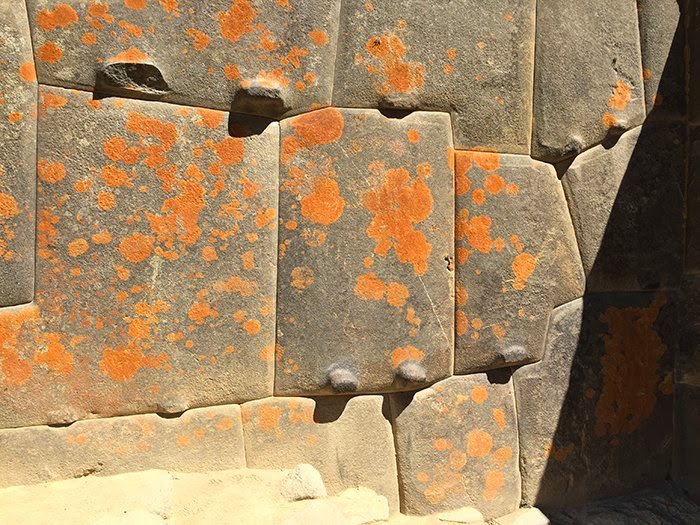


     Dr. Menegat's results indicate the underlying fault-and-fracture network is as integral to Machu Picchu's construction as its legendary stonework (as above). This mortar-free masonry features stones so perfectly fitted together that it's impossible to slide a credit card between them. Aside from the obvious aesthetic benefits of this building style, there are engineering advantages. Peru is a seismically unstable country; both Lima and Cusco have been leveled by earthquakes. When an earthquake occurs, the stones in an Inca building are said to “dance;” that is, they bounce through the tremors and then fall back into place. Without this building method, many of the best known buildings at Machu Picchu would have collapsed long ago.


       "As master stoneworkers, the Incas took advantage of the abundant building materials in the fault zone, says Dr. Menegat. "The intense fracturing there predisposed the rocks to breaking along these same planes of weakness, which greatly reduced the energy needed to carve them."


     "In addition to helping shape individual stones, the fault network at Machu Picchu likely offered the Incas other advantages, according to Dr. Menegat. Chief among these was a ready source of water. "The area's tectonic faults channeled meltwater and rainwater straight to the site," he says. Construction of the sanctuary in such a high perch also had the benefit of isolating the site from avalanches and landslides, all-too-common hazards in this alpine environment, Dr. Menegat explains."


     "The faults and fractures underlying Machu Picchu also helped drain the site during the intense rainstorms prevalent in the region. "About two-thirds of the effort to build the sanctuary involved constructing subsurface drainages," says Dr. Menegat. "The preexisting fractures aided this process and help account for its remarkable preservation," he says. "Machu Picchu clearly shows us that the Incan civilization was an built on well-fractured rocks. 

Have any PEOTS folks visited Machu Picchu? How was the experience?

And Happy 6 year anniversary to PEOTS! 


  • We had a Japanese cardiologist stay with us in March 2008. He took the leftover Colorado trail GORP with him to his next stop at MP and sent this image. So it's almost like I've been there...and it looks deserted.


Thursday, September 14, 2017

Two Hundredth Post: More Continental Crust on South America's Andean Plateau

       This is our 200th blog post and our 48th month of publishing Partial Ellipsis of the Sun! Thanks for your support over the past four years!

      "Seismologists investigating how earth forms new continental crust have compiled more than 20 years of seismic data from a wide swath of South America's Andean Plateau and determined that processes there have produced far more continental rock than previously believed.


     "When crust from an oceanic tectonic plate plunges beneath a continental tectonic plate, as it does beneath the Andean Plateau, it brings water with it and partially melts the mantle, the layer below earth's crust," said Rice University's Dr. Jonathan Delph, co-author of the new study published this week. "The less dense melt rises, and one of two things happens: It either stalls in the crust to crystallize in formations called plutons or reaches the surface through volcanic eruptions."


     Dr. Delph said the findings suggest that mountain-forming regions like the Andean Plateau, which geologists refer to as "orogenic plateaus," could produce much larger volumes of continental rock in less time than previously believed.


     Co-author Dr. Kevin Ward, a researcher at the University of Utah, said, "When we compared the amount of trapped plutonic rock beneath the plateau with the amount of erupted volcanic rock at the surface, we found the ratio was almost 30:1. That means 30 times more melt gets stuck in the crust than is erupted, which is about six times higher than what's generally believed to be the average. That's a tremendous amount of new material that has been added to the crust over a relatively short time period."


     The Andean Plateau covers much of Bolivia and parts of Peru, Chile, and Argentina. Its average height is more than 12,000 feet, and though it is smaller than Asia's Tibetan Plateau, different geologic processes created the Andean Plateau. The mountain-building forces at work in the Andean plateau are believed to be similar to those that worked along the western coast of the U.S. some 50 million years ago. Dr. Delph said it's possible that similar forces were at work along the coastlines of continents throughout Earth's history.


     Most of the rocks that form Earth's crust initially came from partial melts of the mantle. If the melt erupts quickly, it forms basalt, which makes up the crust beneath the oceans on Earth; but there are still questions about how continental crust, which is more buoyant than oceanic crust, is formed. Drs. Delph and Ward spent several months combining public datasets from seismic experiments. Seismic energy travels through different types of rock at different speeds, and by combining datasets that covered a 500-mile-wide swath of the Andean Plateau, Ward and Delph were able to resolve large plutonic volumes that had previously been seen only in pieces.


     Over the past 11 million years, volcanoes have erupted thousands of cubic miles' worth of material over much of the Andean Plateau. Ward and Delph calculated their plutonic-to-volcanic ratio by comparing the volume of regions where seismic waves travel extremely slowly beneath volcanically active regions, indicating some melt is present, with the volume of rock deposited on the surface by volcanoes.


     "Orogenic oceanic-continental subduction zones have been common as long as modern plate tectonics have been active," Dr. Delph said. "Our findings suggest that processes similar to those we observe in the Andes, along with the formation of supercontinents, could have been a significant contributor to the episodic formation of buoyant continental crust."


Happy 200th!
Steph

Thursday, October 13, 2016

Vinicunca Rainbow Mountain in the Andes of Peru: Dr. Seussian Stripes

      The "Rainbow in the Mountain" of Vinicunca in the Andes in Peru is so remote, it is hard to locate on Peruvian maps. Vinicunca doesn't yet have a Wikipedia page (as of today). But, the rainbow will blow you away.


       Located in a remote part of the Andes, somewhere near Cusco, (or Cuzco), Peru, the magical sedimentary layers appear unreal.


      I looked at a few blogs and guided trips to convince myself it really is real.


 From the little geologic research I could find about the area, the Permian formations with their distinct colors of red, ochre, and turquoise sandstones and (possibly) overlying Cretaceous, limestone layers create a wondrous landscape for alpaca, llamas, and horses.


The herding communities in the region constitutes one of the few remaining pastoralist societies in the world. High mountain trails are used by these herders to trade with agricultural communities at lower elevations.


I will see if I can locate the Rainbow Mountain of Vinicunca on Google Earth in the morning. 


Have a go if you'd like!

{It's been a long day. The state of emergency declared in Ethiopia means Zoë will likely be coming stateside in the next 30 days. We just don't know when.}

One more look at the Seussical stripes of Rainbow Mountain in Peru!


Steph

Update: Google Earth view of Rainbow Mountain or Vinicunca


Tuesday, April 29, 2014

Llareta in the Andes, Corn in Kaua'i, and GMOs: Slow Versus Fast Growth


     Llareta is the extremely slow-growing evergreen plant featured on yesterday's NPR Science Friday blog:


     Yes, llareta is real. The photo above is not a poorly photoshopped creation (for you bloggers resizing and reshaping your images ;-)). Azorella compacta is a perennial evergreen and grows close to rocks or soil in order to conserve heat at elevations of 14,000 to over 17,000 feet. Llareta is related to parsley and is quite slow-growing, adding only 1-1.5 centimeters per year. Some of these dense mats of llareta in the Andes Mountains of Chile, Peru, and Argentina have been carbon-dated as being over 3,000 years old. [Alternate carbon-dating definition: chemists getting together for dinner and a movie.]


     The complete article about these dense mats that have, unfortunately, been used in South America as non-renewable fuel is linked here:


               LLARETA OR YARETA


     In comparison, the fast-growing, 3-crop-per-year corn crop in Kaua'i, Hawaii, takes a mere 3-4 months for the entire life cycle. The genetically modified organisms (or GMOs) are pushed to a level of ever-faster change in growth so that modifications to the corn seeds can be made in just 3 years (or, by some accounts, 7 years) instead of at least 13 years in a one-crop-per-year acrigulture. In any case, it's rapid, push it out to market food. In between every corn cycle, the fields are sprayed with Roundup herbicide which kills every broadleaf. Seed agriculture is now Hawaii's number one agricultural business, ahead of cane sugar, pineapples, and other native plants.


     More on GMOs here from earlier this month (the photo credit is in the link below):

GMO Seed Agriculture Growth in Hawaii

     Slow-growing, ancient organisms that have been around for thousands of years or fast-growing corn that has been genetically modified every few months, treated with three rounds a year of Roundup? Which seems safer for animals, including humans, to be around or, in the case of the corn, to actually eat?

       This week's blog honors my mom, June, who has been active in getting people to understand what corporations like Monsanto and its product, Roundup, in their GMO research, are doing with our food. (Over 90 % of U.S. corn is now a GMO product).

        Her best suggestion for us? Plant our own gardens!

         And a final, favorite photo of another very old friend, the bristlecone pine (nearly 5,000 years of very slow growth in CA and other high elevations):


Looking forward to hearing your thoughts on the slow and the fast, the unchanged and the modified, llareta and GMOs (I can wait...),

Word Woman (aka Scientific Steph)