Yes, this is Maizie and me licking our lips (or nose, in her case) at the striking roadcuts of the Ozark Mountains (actually plateaus) of northern Arkansas and the Ouachita Mountains of west-central Arkansas.

The western part of Arkansas includes, from north to south: the Ozark Plateaus or Mountains, the Arkansas River Valley, the Ouachita Mountains, and the West Gulf Coastal Plain. The Ouachita Mountains are one of the few east-west-trending ranges in the U.S. (The Uinta Mountains in Utah and Mt. Tom/Mt. Holyoke Range in Massachusetts are two of the other east-west-trending features.)
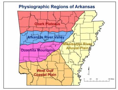
The geologic units are outlined below, including shades of blue for blue-gray Mississippian rocks. (NB: unless one is a geomorphologist, most geologists just gloss over anything coloured yellow for the Tertiary and Quaternary.)

The Mississippian Pitkin Limestone is 360 to 320 years old and is chucky-jam full of fossils, including crinoids and bryozoans. The crinoid stems (which resemble rolls of Smarties candies) are parts of animals called sea-lilies that attached to the seafloor. In this rock sample, which may or may not have travelled from northern Arkansas to Colorado, shows the unweathered fossils.

Here are some weathered out crinoid stems.

And here is the stem and the less-often preserved top of a crinoid animal.

The photo below shows weathered-out screw-shaped bryzoans, commonly referred to as Archimedes screws (in the right bottom part of the photo.) The upper left part of the photo shows the crinoid stem pieces. The crinoids are so plentiful in the Pitkin Limestone that some people apparently fling them on the ground like pop-rocks. We did not partake of that practice.

The Pitkin Limestone overlies the Fayetteville Shale as seen in this roadcut. The "tight" shale is the source of much gas development in Arkansas via hydraulic fracking.

One of the most spectacular parts of our Natural State of Arkansas journey was traveling south along state route 7 from Russellville to Ouachita Hot Springs National Park, right through the heart of the Ouachitas.

Here's the view (with Maizie) toward the Arkansas Valley:

Ouachita Hot Springs National Park:


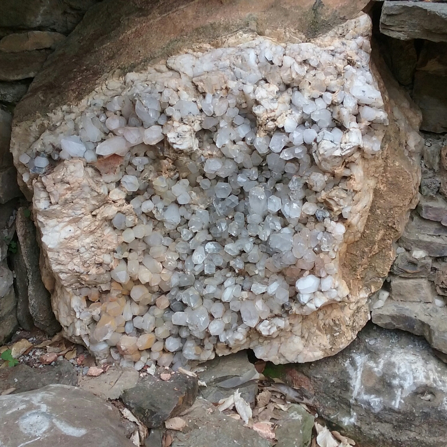
Pictured below are some large quartz crystals from Blue Springs, Arkansas, which are now at the Crystal Bridges American Art Museum grounds in Bentonville.

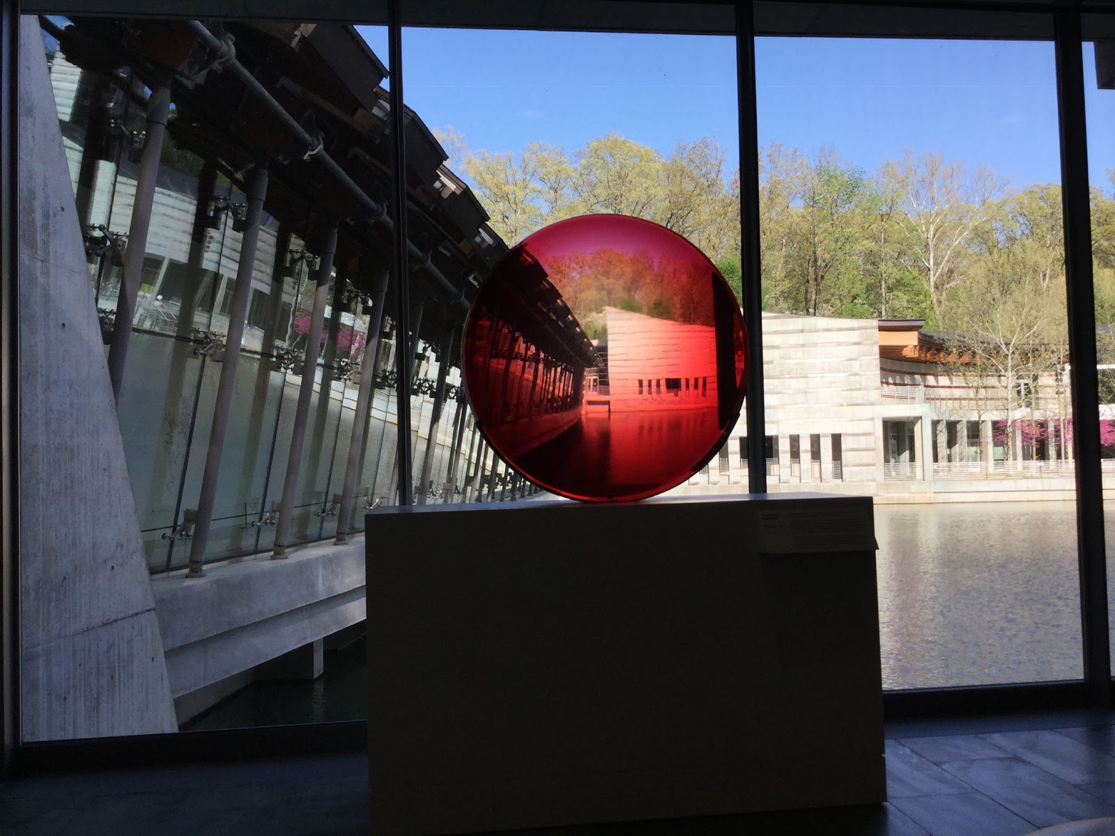
. . .And a few images incorporating geology and art from Crystal Bridges:


And lastly, a beautiful morning with cool mist in the Ozarks somewhere between Mountain Home and Eureka Springs:


Have you explored Arkansas? Hoping you had/have a traveling companion and navigator as amazing as Maizie. . .
Steph

The western part of Arkansas includes, from north to south: the Ozark Plateaus or Mountains, the Arkansas River Valley, the Ouachita Mountains, and the West Gulf Coastal Plain. The Ouachita Mountains are one of the few east-west-trending ranges in the U.S. (The Uinta Mountains in Utah and Mt. Tom/Mt. Holyoke Range in Massachusetts are two of the other east-west-trending features.)

The geologic units are outlined below, including shades of blue for blue-gray Mississippian rocks. (NB: unless one is a geomorphologist, most geologists just gloss over anything coloured yellow for the Tertiary and Quaternary.)

The Mississippian Pitkin Limestone is 360 to 320 years old and is chucky-jam full of fossils, including crinoids and bryozoans. The crinoid stems (which resemble rolls of Smarties candies) are parts of animals called sea-lilies that attached to the seafloor. In this rock sample, which may or may not have travelled from northern Arkansas to Colorado, shows the unweathered fossils.

Here are some weathered out crinoid stems.

And here is the stem and the less-often preserved top of a crinoid animal.

The photo below shows weathered-out screw-shaped bryzoans, commonly referred to as Archimedes screws (in the right bottom part of the photo.) The upper left part of the photo shows the crinoid stem pieces. The crinoids are so plentiful in the Pitkin Limestone that some people apparently fling them on the ground like pop-rocks. We did not partake of that practice.

The Pitkin Limestone overlies the Fayetteville Shale as seen in this roadcut. The "tight" shale is the source of much gas development in Arkansas via hydraulic fracking.

One of the most spectacular parts of our Natural State of Arkansas journey was traveling south along state route 7 from Russellville to Ouachita Hot Springs National Park, right through the heart of the Ouachitas.

Here's the view (with Maizie) toward the Arkansas Valley:

Ouachita Hot Springs National Park:


Pictured below are some large quartz crystals from Blue Springs, Arkansas, which are now at the Crystal Bridges American Art Museum grounds in Bentonville.
. . .And a few images incorporating geology and art from Crystal Bridges:


And lastly, a beautiful morning with cool mist in the Ozarks somewhere between Mountain Home and Eureka Springs:


Have you explored Arkansas? Hoping you had/have a traveling companion and navigator as amazing as Maizie. . .
Steph