Total Pageviews

Showing posts with label limestone. Show all posts

Thursday, March 2, 2017

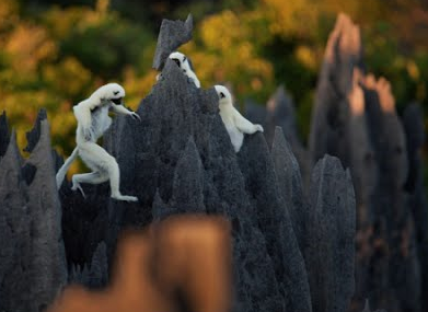
Tsingy, Tsingy, Tsingy: Extreme Karst Topography in Madagascar

      Tsingy de Bemaraha Strict Nature Reserve in Madagascar


is an example of extreme karst topography in very homogenous limestone.


      Due to the sharp nature of the limestone ledges and pinnacles ("tsingy" means "hurts to walk on in barefeet" in Malagasy), it is also home to a wide array of species endemic only to certain parts of the reserve, including a species of lemur (seen here in this 1 minute photo montage).


     The UNESCO World Heritage Site includes these well-defined karst features, shaped by rain with a low pH value (acid rain). The video will also refresh your French.


      The tsingy features are the sedimentary equivalent of the Hawaiian lava called aa. (Though, I can't imagine feeling very "singy" walking on those carbonate ridges, if, indeed, the Malagasy word sounds as I think it does).


      Of course, much of the species diversity at the reserve is due to Madagascar's being separated from the Indian peninsula 88 million years ago (see diagram below). This fourth largest island is a "biodiversity hotspot;" over 90% of its wildlife is found nowhere else on earth due to its geographic isolation. 


      The microclimate of the Tsingy Nature Reserve created even further specialized plants and animals.


            So, the dilemma: do Madagascans go out for Indian food or perhaps food from Mozambique?


      Surely, it's a delicate balance.


      And please, you must remember this. . .


Have any of you been to the Tsingy Reserve? Eaten food from Mozambique? (I am assuming Indian food is on the table already. . .)

Steph

It's all about perspective:


Thursday, October 13, 2016

Vinicunca Rainbow Mountain in the Andes of Peru: Dr. Seussian Stripes

      The "Rainbow in the Mountain" of Vinicunca in the Andes in Peru is so remote, it is hard to locate on Peruvian maps. Vinicunca doesn't yet have a Wikipedia page (as of today). But, the rainbow will blow you away.


       Located in a remote part of the Andes, somewhere near Cusco, (or Cuzco), Peru, the magical sedimentary layers appear unreal.


      I looked at a few blogs and guided trips to convince myself it really is real.


 From the little geologic research I could find about the area, the Permian formations with their distinct colors of red, ochre, and turquoise sandstones and (possibly) overlying Cretaceous, limestone layers create a wondrous landscape for alpaca, llamas, and horses.


The herding communities in the region constitutes one of the few remaining pastoralist societies in the world. High mountain trails are used by these herders to trade with agricultural communities at lower elevations.


I will see if I can locate the Rainbow Mountain of Vinicunca on Google Earth in the morning. 


Have a go if you'd like!

{It's been a long day. The state of emergency declared in Ethiopia means Zoƫ will likely be coming stateside in the next 30 days. We just don't know when.}

One more look at the Seussical stripes of Rainbow Mountain in Peru!


Steph

Update: Google Earth view of Rainbow Mountain or Vinicunca


Tuesday, November 19, 2013

Cheese Imitates Geology: Thin Vegetable Ash Layer and Thin Iridium-rich Clay Layer

Cheese Imitates Geology: Thin Vegetable Ash Layer and Thin Iridium-Rich Clay Layer


      There is a small, wicker cheese basket at my local grocery store filled with little snippets of cheeses--the ends of various imported wheels and logs. This one caught my eye:


          I unwrapped it last night and found this written on the wrapper (just so you know I'm not making this up):


     A hairline layer of vegetable ash?! Oh my. 

     Of course, the iridium-rich clay layer found at the boundary of the Cretaceous period (about 65 million years ago) with the overlying Paleogene sediments first documented by Luis and Walter Alvarez (shown below) in Italy, sprang to mind. The limestone layers beneath the red clay are full of numerous species of foraminifera (forams) and the thick limestone beds above contain only one foram species. In between is this iridium-rich later of clay. In Italy. In Germany. In the Netherlands. In the U.S. All over the world.


      Iridium is a rare, silvery, white transition metal of the platinum family found in meteorites. It was named for the Greek goddess Iris after the rainbow colors in its salts and less than 3 tons a year are mined world-wide:


     Iridium is associated with the massive K-Pg extinction including the non-flying dinosaurs and a huge, diverse, plant population. (The boundary was called the K-T boundary for Cretaceous-Tertiary when the Alvarezes discovered it. The International Stratigraphic Nomenclature Committee has recently deprecated the Tertiary Period though; it now must be called Paleogene.) [First Pluto is no longer a planet; now we can't call it the K-T boundary any more. Sigh...]  And the likely location of the meteorite hitting the earth in the Gulf of Mexico is also well documented.

       What strikes me (no pun intended, okay, maybe...) about naming conventions in geology and in all areas, actually, is the creativity and force in coming up with these descriptive terms. As Clementine says to Joel when talking about her newest hair color in the film Eternal Sunshine Sunshine of the Spotless Mind, "Naming hair colors. Somebody has that job. I want that job!"


        Calling the thin layer of vegetables in the Humboldt Fog Cheese "Vegetable Ash" is truly inspired to this geologist and cheese eater.

         Last week: puddingstones that look like pudding. This week: Cheese that looks like limestone layers with a hairline layer of ash. It doesn't get much better than that full circle.

        Thanks for reading. I look forward to your comments, thoughts, and cheesy ideas.


Until then, "say cheese!" (And mean it).

Humboldtly yours,
Word Woman (aka Scientific "Vegetable Ash Layer" Steph)